How are drones used for construction? – DSLRPros Official Blog

The uses for drones are constantly expanding as new sensors and software are being implemented. We’ve covered uses for public safety including Police, Firefighting, and Search and Rescue. The uses certainly do not stop there. One of the most rapidly expanding drone industries is the use of drones for construction.
MAPPING
Aerial mapping is by far the most important drone functionality for construction companies. From initial planning to progress monitoring, aerial maps are invaluable.
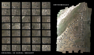
Photo: https://dronemapper.com/
Orthomosaic: An orthomosaic image is multiple aerial photographs stitched together and geometrically corrected so that the scale is uniform. Once the orthomasic imagine is created, users can zoom into each individual picture getting a closer look at the desired area. An orthomosaic image can also be used to measure distances between points within the picture, providing additional information from the mapped area.
Orthomosaic images from drones are particularly helpful because they can be created and updated relatively quickly to give up-to-date maps of real conditions on the ground. This gives construction companies the ability to accurately plan for deliveries, equipment movement, or excavation on a job site, saving valuable time.
3D Maps: Three-dimensional mapping is the process of gathering location information with images from multiple angles so that the locations and the attributes of the items can be displayed and rendered from different angles. Much like the interactive map below.
“Read the full blog post on DSLRPros.com“


